By Michael Lanza
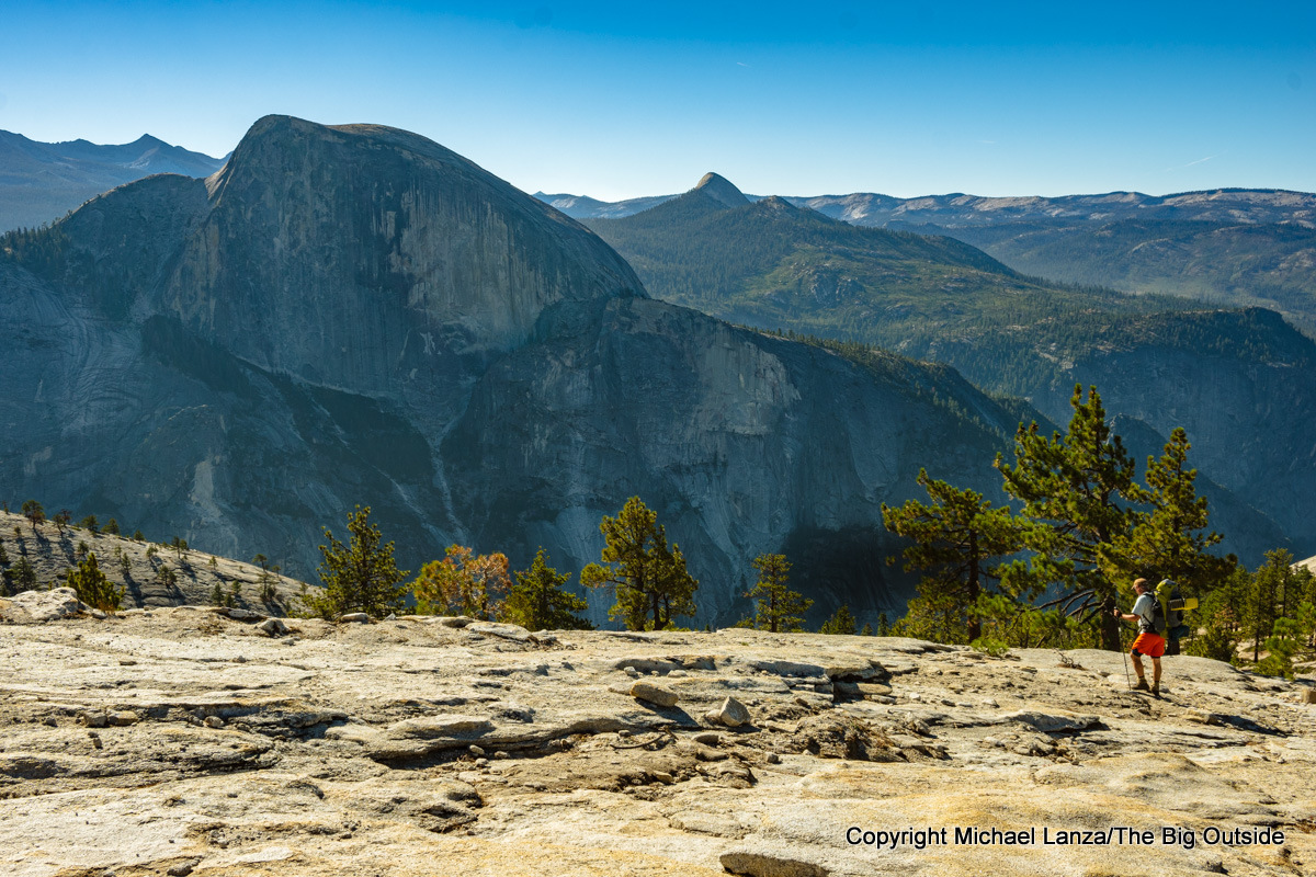
So you’re a novice backpacker, or you’re planning your first backpacking trip in a big, Western national park, or you have kids you want to take on a relatively easy backpacking trip—and you want to sample the best scenery, trails, and backcountry campsites that experienced backpackers get to enjoy in our national parks. No worries. These 10 trips in Grand Teton, Zion, Grand Canyon, Glacier, Olympic, Rocky Mountain, Mount Rainier, Canyonlands, and two in Yosemite (photo above) are ideal for beginners and families, with easy to moderately difficult days and simple logistics, while delivering the spectacular vistas that each of these parks is famous for.
In fact, two of them (Yosemite and Grand Teton) were among the very first multi-day hikes I took as a novice backpacker more than three decades ago, and seven (Zion, Grand Teton, Glacier, Grand Canyon, Olympic, Mount Rainier, and Rocky Mountain) were among my kids’ earliest trips, which we took when they ranged in age from six to 10. They are also among the nicest multi-day hikes I’ve taken over more than three decades (and counting) of carrying a backpack, including the 10 years I spent as a field editor for Backpacker magazine and even longer running this blog.

Besides delivering on all you expect from a backpacking trip in a flagship national park, any of these outings will help prepare you for bigger, more ambitious adventures.
I can help you plan any of them—or any trip you read about at this blog, including beginner-friendly backpacking trips not in national parks, avoiding the need to reserve a permit months in advance. See my Custom Trip Planning page.
See also my stories “The 10 Best National Park Backpacking Trips,” “How to Plan a Backpacking Trip—12 Expert Tips,” and “10 Tips for Taking Kids on Their First Backpacking Trip.”
Please tell me what you think of these trip ideas or offer your own in the comments section at the bottom of this story. I try to respond to all comments.

Grand Teton’s Paintbrush-Cascade Canyons Loop
Distance: 19.7 miles
Difficulty: Moderate
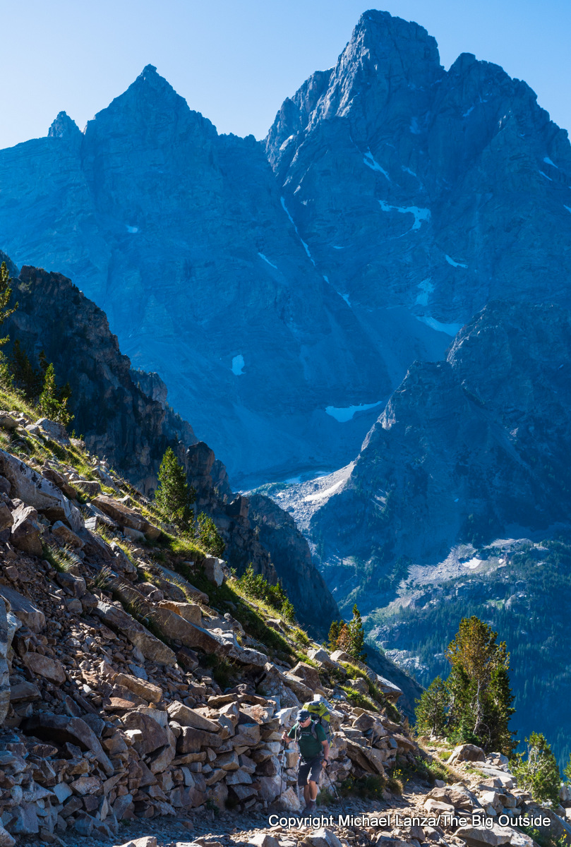
The 19.7-mile loop linking up Paintbrush and Cascade canyons from String Lake offers something of a highlights reel of Grand Teton National Park and is undoubtedly among the most scenic sub-20-mile, multi-day hikes in the National Park System. With nearly 4,000 feet of elevation gain and loss, the loop crosses one of the highest points reached via trail in the park, 10,720-foot Paintbrush Divide, where the panorama takes in a jagged skyline featuring some of the highest summits in the Tetons. It also passes by beloved Lake Solitude, nestled in a cirque of cliffs, and below the striped cliffs of Paintbrush Canyon and waterfalls and soaring peaks of Cascade Canyon.
We backpacked this popular loop over three days with our kids when they were young, camping at Upper Paintbrush the first night and North Fork Cascade the second, and seeing moose in Cascade Canyon; I’ve also dayhiked it. It can be hiked in either direction—and the Paintbrush side is steeper and more strenuous whether going up or down it. But by going counter-clockwise, you enjoy a steady view of the Grand Teton looming high above the North Fork of Cascade Canyon; and you finish down Cascade Canyon, where most of the group can avoid the final slog through the woods and take the boat shuttle across Jenny Lake—with in-your-face views of the peaks—while someone hikes the last 45 minutes to retrieve the car at String Lake.
Click here now to get my expert e-guide to this beginner-friendly backpacking trip in Grand Teton National Park.
I can personally help you plan this trip (or any trip you read about at my blog), from permit to daily hiking plan, through my custom trip planning; click here to learn how—and to read comments from others who’ve received my custom trip planning, many of which were for backpacking in the Tetons.
See all stories about backpacking in Grand Teton National Park at The Big Outside (some of which require a paid subscription to read in full), including “A Wonderful Obsession: Backpacking the Teton Crest Trail,” “The 5 Best Backpacking Trips in Grand Teton National Park,” “How to Get a Permit to Backpack the Teton Crest Trail,” and “Walking Familiar Ground: Reliving Old Memories and Making New Ones on the Teton Crest Trail” about taking our kids at young ages on the TCT.
Find your next adventure in your Inbox. Sign up now for my FREE email newsletter.

The Best First Trip in the Grand Canyon
Distance: 21 to 23.5 miles
Difficulty: Moderate to strenuous
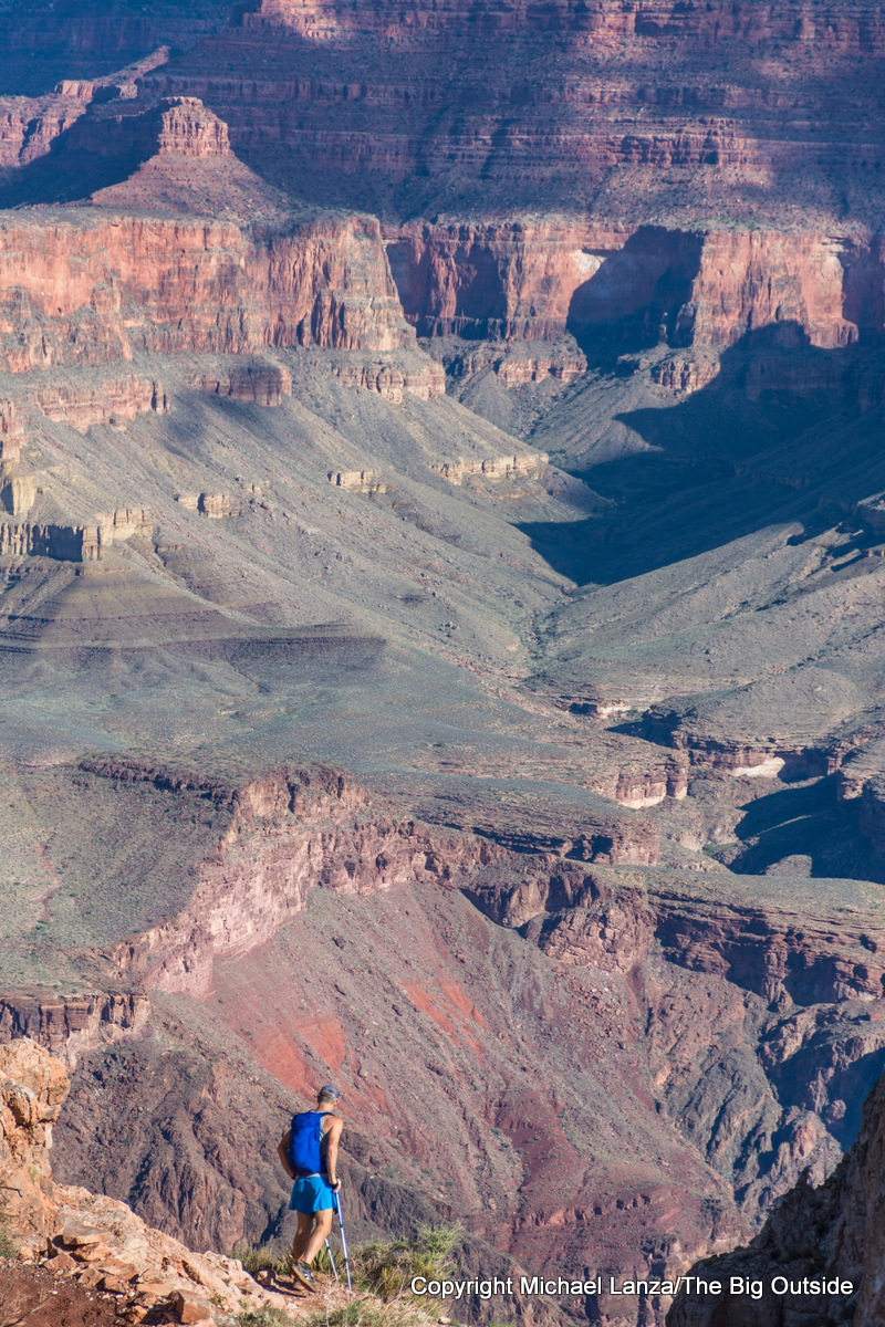
While this is one of the most strenuous trips on this list, for beginner backpackers or families with good stamina who are up for a somewhat bigger challenge, crossing the Grand Canyon from rim to rim constitutes one of the most scenically astonishing experiences in the entire National Park System. Beginning at either the South or North Rim, you will descend through a constantly changing environment and multiple layers of geology, from vistas encompassing a huge swath of the canyon to intimate side canyons with rushing creeks and waterfalls.
The distance ranges from 21 to 23.5 miles depending on whether you combine the South Kaibab Trail or Bright Angel Trail with the North Kaibab Trail, and the cumulative elevation gain and loss is well over 10,000 feet. Many backpackers spread it over three days. Still, water sources are regular and you’re hiking the best-constructed trails in the entire canyon.
Want a shorter Grand Canyon sampler? Hike 16.5 miles rim to river to rim: down the South Kaibab Trail and up the Bright Angel Trail over two or three days, with one night at Bright Angel Campground on the Colorado River and a possible second night at Indian Garden Campground along the Bright Angel Trail to break up the long climb back up from the river.
See my story “Fit to Be Tired: Hiking the Grand Canyon Rim to Rim in a Day” for photos from this trip and my tale of dayhiking rim to rim, and “8 Epic Grand Canyon Backpacking Trips You Must Do.”
Click here now for my expert e-guide to backpacking the Grand Canyon rim to rim.

The Magnificent Heart of Yosemite
Distance: 37.2 miles (shorter options)
Difficulty: Moderate
Anyone looking for a five-star introduction to backpacking in Yosemite that hits marquis highlights and is beginner-friendly need look no further than this 37.2-mile loop from Yosemite Valley. From the popular Happy Isles Trailhead at the east end of The Valley, it winds through the core of the park, starting with ascending the Mist Trail past 317-foot Vernal Fall—which rains a heavy mist on hikers—and thunderous, 594-foot Nevada Fall. The distance includes the optional, out-and-back climb of the steep and exposed cable route up Half Dome, where the summit view of Yosemite Valley is arguably only outdone by the view you’ll get later on the hike from a thousand feet higher on the knife-edge summit ridge of Clouds Rest.

From a campsite on the edge of the alpine meadows at Sunrise, you’ll get a sweeping view of the granite castles of the Cathedral Range. And the hike, spread over four to five days, follows a couple stretches of the world-famous John Muir Trail, descending it on the last day past a calendar-photo vista of Half Dome, Liberty Cap, and Nevada Fall. Apply early for this permit reservation, especially if you want to spend more than one night camping at Little Yosemite Valley.
See my story “Where to Backpack First Time in Yosemite” for a description of this route, and a more-detailed description with complete trip-planning guidance in my e-guide “The Best First Backpacking Trip in Yosemite,” which also covers alternate multi-day hiking itineraries beginning and ending at various trailheads ringing this core area of the park, including routes from Tuolumne Meadows and stunning Tenaya Lake. Click here for a menu of all downloadable e-guides I offer, including three trips in Yosemite.
And check out “The 8 Best Backpacking Trips in Yosemite,” “Hiking Half Dome: How to Do It Right and Get a Permit,” and all of my stories about backpacking in Yosemite National Park.
Want to read any story linked here?
Join now to read ALL stories and get a free e-guide and gear discounts!

Glacier’s Glorious Gunsight Pass Trail
Distance: 20 miles
Difficulty: Moderate

Much of the more than 700 miles of trails in one-million-acre Glacier National Park traverse remote wilderness, requiring a commitment of multiple days backpacking in northern mountains thick with grizzly bears, where weather can shift. But the 20-mile traverse of the Gunsight Pass Trail, from Gunsight Pass Trailhead to Lake McDonald Lodge, is one of the logistically easiest and shortest multi-day hikes in the park. Both trailheads are on the Going-to-the-Sun Road and served by the park’s free shuttle bus.
Most of all, though, the hike takes in some of the park’s best scenery, including one of its largest rivers of ice, the Blackfoot Glacier (seen from a distance), scores of waterfalls, and backcountry camps at Gunsight Lake and Lake Ellen Wilson that rank among the prettiest in the park.
Spread it out over four days and add the optional, 6.6-mile, out-and-back side hike to Sperry Glacier—which involves more than 1,700 vertical feet of up and down and some steep sections, making it a fairly demanding side hike for many adults and children. That trail climbs over a barren, rocky, more recently deglaciated landscape, and passes through a narrow notch in the cliffs at Comeau Pass to reach an overlook of the Sperry Glacier.
Unlike trails around Logan Pass and Many Glacier, this route is not crowded with dayhikers. I’ve backpacked it twice—the second time with our kids when they were nine and seven, taking three days—and saw mountain goats near Gunsight Pass both times. The moderately graded trail never gets terribly steep, so it feels easier than the distances suggest, although the long descent to Lake McDonald is a thigh-pounder; still, hike it east to west because in the other direction, the day one uphill from Lake McDonald would be a strenuous and long slog, much of it exposed to the hot sun.
See my story “Jagged Peaks and Wild Goats: Backpacking Glacier’s Gunsight Pass Trail,” “5 Reasons You Must Backpack in Glacier National Park,” “10 Backpacking Trips for Solitude in Glacier National Park,” and all stories about backpacking in Glacier National Park at The Big Outside.
See my five-level difficulty rating system in “How to Know How Hard a Hike Will Be.”
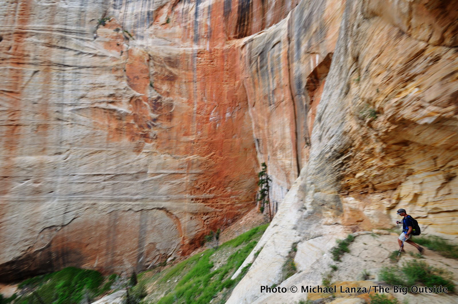
Zion’s Otherworldly West Rim Trail
Distance: 14 miles
Difficulty: Moderate

Only in a national park that features The Narrows—which, admittedly, ranks hands-down as one of the best backpacking trips in America and certainly one of the best in the Southwest—could the West Rim Trail be overshadowed. More than a few longtime Zion backcountry denizens have told me the West Rim is their favorite trail in the park—and having dayhiked and backpacked it, I’d say it is, in many ways, just as enchanting as The Narrows. From the plateau on the trail’s upper sections, you overlook a labyrinth of white-walled canyons and green-topped mesas. Then the trail drops about 2,500 feet in 4.7 miles, zigzagging down a cliff face and through a landscape of towering beehive rock formations and walls streaked in vivid burgundy and salmon hues.
The approximately 14-mile, one-way, north-to-south, mostly downhill hike from Lava Point on Kolob Terrace Road to the Grotto Trailhead in Zion Canyon—requiring a shuttle (available in Springdale)—can be done in one day by fit hikers. But an overnight at one of the campsites along the West Rim Trail lets you see this incomparable scenery in the glorious light after dawn and at sunset, and makes it a more feasible objective for families and novice backpackers. Add just just under a mile for the side hike up Angels Landing, one of the most spectacular and iconic summits in the National Park System.
See my stories about a family backpacking trip on the West Rim Trail, a 50-mile dayhike across Zion that included the West Rim Trail, my e-guide to a two-day backpacking trip through Zion’s incomparable Narrows (another relatively beginner-friendly trip), and all of my stories about Zion at The Big Outside.
See also “The 5 Southwest Backpacking Trips You Should Do First,” and read this story about another easy, one- or two-night hike in Capitol Reef National Park’s Spring Canyon.
I can help you plan any trip you read about at my blog. Find out more here.
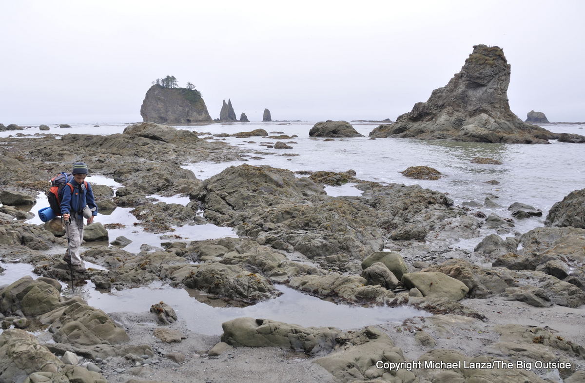
The Wild Olympic Coast
Distance: 17.5 miles
Difficulty: Easy to Moderate

Along the 73 miles of seashore within Olympic National Park, you can’t buy fried seafood, ice cream, or a T-shirt. The longest strip of protected wilderness coastline in the contiguous United States, it’s one of the few remaining pieces of ocean-view real estate in the Lower 48 that the explorer Capt. George Vancouver would recognize.
Backpacking the 17.5-mile southern stretch of the Olympic coast from the Hoh River north to La Push Road became one of my kids’ most memorable backpacking trips—mostly for the hours they spent playing in tide pools on the beach (they were nine and seven at the time). But it’s also a hike any adults would find gorgeous and fascinating.
You will walk surprisingly rugged and muddy overland trails in the deep shade of giant trees in one of Earth’s largest virgin temperature rainforests, and scale rope ladders dangling down eroding headlands. Along the beach, you will pass tide pools and boulders teeming with sea stars, mussels, and sea anemones, with sometimes mist-shrouded views of scores of tall stone pinnacles, called sea stacks, rising out of the ocean, some close enough to walk to them at low tide. You may sight seals, sea otters, whales (and to my kids’ delight, lots of slugs).
A fun, beautiful, beginner- and family-friendly trip, especially with school-age kids, it’s also less crowded than the more popular northern stretch of the Olympic coast, an easier permit to obtain—and one of America’s most unique backpacking adventures.
See my story “The Wildest Shore: Backpacking the Southern Olympic Coast.”
See my “10 Tips for Taking Kids on Their First Backpacking Trip”
and my very popular “10 Tips For Raising Outdoors-Loving Kids.”

Wild Basin, Rocky Mountain National Park
Distance: Multiple short options
Difficulty: Easy

In the southeast corner of Rocky Mountain National Park, east of the Continental Divide and south of the park’s tallest and most famous mountain, 14,259-foot Longs Peak, Wild Basin holds a small constellation of mountain lakes rippling below a wall of 12,000- and 13,000-foot peaks. In the forest of ponderosa pine with copses of aspen trees that turn golden in fall, trails reach like the fingers on a hand up creek valleys to access several of the lakes on relatively easy hikes, presenting a variety of route options.
From the Wild Basin Trailhead at 8,500 feet, it’s just a few miles gently uphill to creekside campsites like Siskin, on a small creek where my kids played on a family backpacking trip. Six miles in lies Thunder Lake, in a bowl at over 10,500 feet, beneath the rampart of the Divide. The best camp we had was the lone site at Ouzel Lake, a jewel at about 10,000 feet ringed by pine forest below more soaring peaks. From there, our hike out consisted of an easy 4.7 miles downhill. While parts of Wild Basin get significant dayhiker traffic, Ouzel Lake and Thunder Lake both lie far enough from the trailhead to see fewer dayhikers, and you’ll enjoy quiet evenings and mornings of glassy water to yourself.
See my story about backpacking in Rocky Mountain National Park’s Wild Basin with my kids.
Gear up smartly for your trips.
See a menu of all reviews and expert buying tips at The Big Outside’s Gear Reviews page.

Mount Rainier’s Mowich Lake to Sunrise
Distance: 22 miles
Difficulty: Strenuous
When our kids were nine and seven years old—with more than a few backpacking trips under their belts—we took them on this nearly 22-mile hike from Mowich Lake to Sunrise, on The Mountain’s dramatic north side, via the Spray Park Trail and the Wonderland Trail.

Feasible for reasonably fit backpackers in three days (we took four days with our young kids), this traverse follows the Spray Park Trail past Eagle Cliff’s overlook of Mount Rainier and the spur path to Spray Falls (worth the 15-minute out-and-back walk) and emerges from lush rainforest to the wildflower meadows of Spray Park, at the foot of The Mountain. After a long descent to rejoin the Wonderland Trail, it crosses the suspension bridge over the roaring Carbon River and ascends above the Carbon Glacier to a Wonderland Trail highlight, Mystic Lake. Beyond the lake lie more views of Rainier’s biggest glaciers, log bridges over glacial rivers, and the meadows of Berkeley Park and Sunrise, where mountain goat sightings are common.
Don’t underestimate the difficulty: This entails over 12,000 vertical feet of combined uphill and downhill, making it the most strenuous hike on this list. It also requires a vehicle shuttle between Mowich Lake and Sunrise and there are no commercial shuttle services operating in Mount Rainier National Park.
See my story about our family trip, “Wildflowers, Waterfalls, and Slugs at Mount Rainier” and all stories about backpacking in Mount Rainier National Park at The Big Outside. This trip is described in more detail as an alternate itinerary in my e-guide “The Complete Guide to Backpacking the Wonderland Trail in Mount Rainier National Park.”
Yosemite Valley’s Quiet North Rim
Distance: 15 to 25 miles
Difficulty: Moderate
We don’t tend to think of Yosemite Valley as one of the park’s quiet corners—especially during the peak hiking season, when on any given day, you’ll encounter hundreds of hikers parading up and down the Mist Trail. But the Valley’s North Rim seems to lie a world apart from all that.
Not easily reached on a dayhike—but certainly within range for a moderate, two- to three-day backpacking trip—Indian Ridge, North Dome, and Yosemite Point, not to mention obscure spots along the rim, are among the finest overlooks of Yosemite Valley. Traversing the North Rim on a longer backpacking trip, a friend and I had a high camp all to ourselves a short walk from the top of an unnamed dome, where we watched, transfixed, a glorious sunset slowly unfurl.
The next morning, we hiked along the nearly treeless southern end of Indian Ridge and onto the broad summit of North Dome, some 3,000 feet above the Valley—stepping into a heart-stopping scene, with the sheer face of Half Dome looming enormous just across the deep chasm of Yosemite Valley. Our view spanned from Clouds Rest to Glacier Point, El Capitan, and beyond. And other than a few dayhikers, we had it to ourselves on a perfect, late-summer morning.
Let The Big Outside help you find the best adventures.
Join now for full access to ALL stories and get a free e-guide and member gear discounts!
Trailhead access enables a variety of two- to four-day itineraries and the route’s highest elevations are around 8,500 feet, while much of it lies below 8,000 feet, elevations that don’t tend to affect many people and which become snow-free by early summer.
Read about “Yosemite’s Best-Kept Secret Backpacking Trip.”
There are other relatively short, beginner-friendly trips possible in Yosemite that I can help you plan. See my Custom Trip Planning page as well as “The 8 Best Backpacking Trips in Yosemite” and all stories about backpacking in Yosemite National Park.
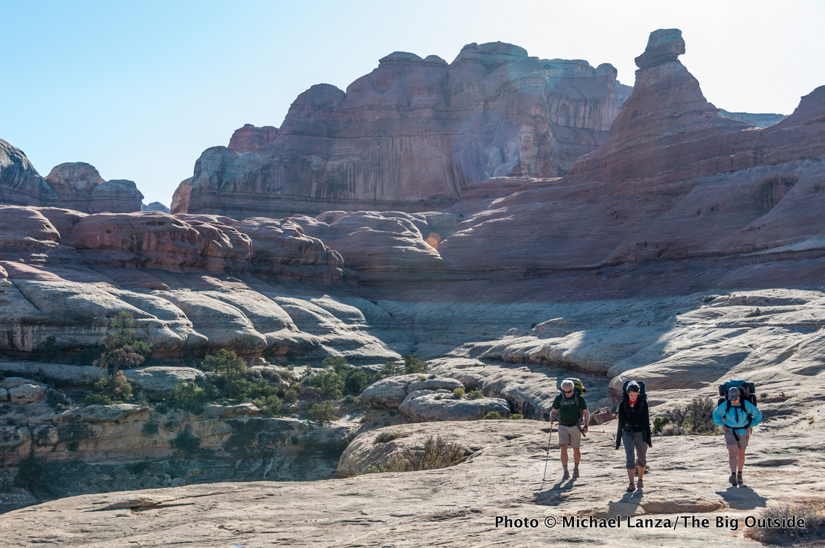
The Needles District in Canyonlands
Distance: 7.5 to 20+ miles
Difficulty: Easy to Moderate

Even in the Southwest, the Needles District stands out for its unique landscape of multi-colored candlesticks of Cedar sandstone rising to 300 feet tall and stratified cliffs stretching for miles. The Needles also has over 60 miles of trails zigzagging over a high plateau spliced by canyons—but without the severe elevation gain and loss of other Southwest canyons.
While water is scarce, you don’t have to hike great distances to reach backcountry campsites and explore. And established trails to Chesler Park, Big Spring, Squaw, and Lost canyons, and the Peekaboo Trail are easy to follow.
On a three-family trip one early spring, we backpacked an easy overnighter on the 7.5-mile loop from Squaw Flat campground up Big Spring Canyon and down Squaw Canyon, with a few adults in the group tacking on another five to six miles by hiking down Lost Canyon and out the Peekaboo Trail. I’ve also backpacked an approximately 20-mile hike through Chesler Park—including The Joint Trail, which passes through a very narrow slot canyon—and Elephant Canyon, a route that offers an optional side trip see 450-foot-tall Druid Arch.
See my story “No Straight Lines: Backpacking and Hiking in Canyonlands and Arches National Parks,” and all stories about Canyonlands National Park at The Big Outside.
See menus of all stories about national park trips and family adventures at The Big Outside.
Whether you’re a beginner or seasoned backpacker, you’ll learn new tricks for making all of your trips go better in my “How to Plan a Backpacking Trip—12 Expert Tips,” “A Practical Guide to Lightweight and Ultralight Backpacking,” and “How to Know How Hard a Hike Will Be.” With a paid subscription to The Big Outside, you can read all of those three stories for free; if you don’t have a subscription, you can download the e-guide versions of “How to Plan a Backpacking Trip—12 Expert Tips,” the lightweight and ultralight backpacking guide, and “How to Know How Hard a Hike Will Be.”