By Michael Lanza
The imminent end of summer always feels a little melancholy. After all, it marks the close of the prime season for getting into the mountains. But it also signals the beginning of a time of year when many mountain ranges become less crowded just as they’re hitting a sweet zone in terms of temperatures, the lack of bugs, and fall foliage color. Autumn also stands out as an ideal season for many Southwest hikes, with moderate temperatures and even some stunning color.
From Yosemite to Yellowstone, Grand Canyon to Grand Teton, the Great Smokies to the White Mountains and hikes that may not be on your radar, like the Ruby Crest Trail, North Cascades (lead photo, above), and Aravaipa Canyon, here are 12 backpacking trips that get even better in fall—all of them standouts among the innumerable trips I’ve taken over the past three-plus decades, including 10 years as Northwest Editor at Backpacker magazine and even longer running this blog.
 Hi, I’m Michael Lanza, creator of The Big Outside. Click here to sign up for my FREE email newsletter. Join The Big Outside to get full access to all of my blog’s stories. Click here for my e-guides to classic backpacking trips. Click here to learn how I can help you plan your next trip.
Click on links below to read the feature-length stories about these trips, which contain numerous photos and often a video. While much of those individual stories is free for anyone to read, reading them in full, including my tips on planning those trips, is an exclusive benefit for readers with a paid subscription to The Big Outside. See also my expert e-guides to several classic backpacking trips and my Custom Trip Planning page to learn how I can help you plan any of these adventures or any trip you read about at The Big Outside.
Don’t stay home and lament the end of summer—get out and make the most of autumn, an ideal time of year in the backcountry.
Please share your thoughts, questions, or suggestions for fall backpacking trips in the comments section at the bottom. I try to respond to all comments. Click any photo to read about that trip.

Aravaipa Canyon Wilderness
“Ara-what?” Yea, that was my reaction when I first heard about this place from a friend—whose tip I wisely followed. (Thanks, John.) Five of us backpacked into Aravaipa for three days, dayhiking from a base camp to explore this lush green, 12-mile-long defile between redrock walls that reach up to 600 feet tall.
Although tiny compared to many more-famous public lands, the 19,410-acre Aravaipa Canyon Wilderness, in southeast Arizona, stands out as an anomalous Southwest oasis in the hyper-arid Sonoran Desert. Aravaipa Creek flows strongly year-round, nurturing tall cottonwood, sycamore, ash, and willow trees in the canyon bottom, while saguaro cacti grow in giant armies on the rims overhead. With easy, nearly flat hiking often in the shallow river, no water scarcity typical of Southwest desert backpacking trips, abundant shade, the low elevation and southern Arizona climate, Aravaipa offers a relatively casual and beautiful adventure in spring and fall—but fall paints the canyon in brilliant hues of red and gold.
See my story “Backpacking the Desert Oasis of Aravaipa Canyon.”
Find your next adventure in your Inbox. Sign up now for my FREE email newsletter.

The High Sierra
Like Yosemite (below), demand for wilderness permits throughout the High Sierra, especially in Sequoia-Kings Canyon national parks and the John Muir and Ansel Adams wildernesses, grows fierce during the summer. But most backpackers fail to realize that the real peak season for exploring the incomparable High Sierra begins later in August—when the wilting afternoon heat and ravenous mosquitoes of early to mid-summer start to abate—and often continues through September and into October.

And the options are virtually unlimited in this contiguous wilderness spreading over nearly three million acres—an ocean of jagged peaks rising as high as 14,000 feet and a constellation of shimmering alpine lakes—from weekend trips to a week or longer, including five-star section hikes of the John Muir Trail and Pacific Crest Trail or variations off them into less-well-known corners of the Sierra. After backpacking many hundreds of miles throughout the Sierra over more than three decades, I have yet to run out of great hikes to do there.
See all stories about High Sierra backpacking trips at The Big Outside, including “How to Get a Yosemite or High Sierra Wilderness Permit,” “Backpacking the John Muir and Ansel Adams Wildernesses,” “10 Great John Muir Trail Section Hikes,” and “Thru-Hiking the John Muir Trail: What You Need to Know.”
I can help you plan any trip you read about at my blog. Click here to learn how.

North Cascades National Park
In the last week of September, with huckleberries ripe and tasty and the larch trees blazing yellow with fall color (lead photo at top of story), a friend and I took an 80-mile hike through the heart of the North Cascades National Park Complex, a sprawling swath of heavily glaciated mountains and thickly forested valleys. Our grand tour from Easy Pass Trailhead to Bridge Creek Trailhead took us through virgin forests of giant cedars, hemlocks, and Douglas firs, and over four passes, including Park Creek Pass, where waterfalls and glaciers pour off cliffs and jagged, snowy peaks.
We enjoyed five sunny, glorious early-fall days; but of course, snow can fall in these mountains in September, so watch the forecast. North Cascades has long been one of my favorite parks (it has one of the most inspiring backcountry campsites I’ve ever slept in). But not many backpackers know this place: It’s one of America’s least-visited national parks. That’s good if you like to have a beautiful wild place to yourself.
See my story “Primal Wild: Backpacking 80 Miles Through the North Cascades,” which has my tips on how to plan and take this trip, including shorter variations of the 80-mile route, and all of my stories about North Cascades National Park.
I can help you plan a backpacking trip of almost any length in the North Cascades. See my Custom Trip Planning page to learn how.
Plan your next great backpacking trip in Yosemite, Grand Teton,
and other parks using my expert e-guides.
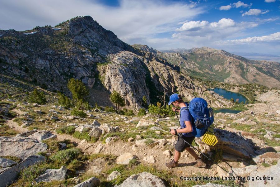
Ruby Crest Trail
Maybe like me, you’ve had Nevada’s Ruby Crest Trail in your sights for several years. When I finally made it there, I wondered why I’d waited so long.
The four-day, approximately 36-mile traverse of the Ruby Crest Trail goes from a high-desert landscape speckled with granite monoliths to aspen and conifer forests and alpine terrain high above treeline, with constant views of the craggy Ruby Mountains. We passed some stunning mountain lakes—one of which ranks among the prettiest backcountry lakes and best backcountry campsites I’ve had the pleasure to enjoy.
While my family backpacked the Ruby Crest Trail in mid-July, when wildflowers bloom and moderate temperatures prevail, late summer and early fall bring even greater solitude to a wilderness that sees relatively few backpackers and dayhikers compared to many parks and mountain ranges. If you’re trying to pull together a last-minute trip, the Ruby Crest Trail also offers the convenience of requiring no permit reservation.
See my story “Backpacking the Ruby Crest Trail—A Diamond in the Rough.”
Want to read any story linked here?
Join now to read ALL stories and get a free e-guide and gear discounts!

Yellowstone National Park
Imagine this: You’re partway through a wilderness backpacking trip when you reach a natural hot spring-fed pool in the backcountry… and soak for hours. That’s what awaits you in Yellowstone’s Bechler Canyon, where the famous Mr. Bubble forms a wide, hot pool at a perfect temperature for soaking.
A friend and I enjoyed a long soak in Mr. Bubble on a five-day, roughly 55-mile hike through Bechler Canyon. We also saw thunderous waterfalls and cascades along the Bechler River Trail, which also, in sections, is a quiet, tree-lined waterway with world-class trout fishing. We saw a black bear, heard elk bugling, and explored the largest backcountry geyser basin in the park—which we had almost entirely to ourselves.
September and early October are the best months to backpack in this corner of Yellowstone—after the notorious summer mosquito season, with frequently pleasant weather, when the multiple, cold fords of the Bechler get a bit lower.
See my story about that trip “In Hot (and Cold) Water: Backpacking Yellowstone’s Bechler Canyon” at The Big Outside.
Time for a better backpack? See my picks for “The 10 Best Backpacking Packs”
and the best ultralight packs.

Great Smoky Mountains National Park
Unquestionably one of the East’s premier backpacking destinations, the Great Smokies have two peak seasons: spring, when about 1,600 species of flowering plants—more than found in any other national park—come into bloom; and fall, when dry air and moderate temperatures settle in, insects have mostly disappeared, and the forest paints itself in the brilliant hues of autumn foliage. While you’ve probably seen many photos of the classic vistas from Great Smokies summits of overlapping rows of blue, wooded ridges fading to a distant horizon, I’ve found that much of the park’s magic resides in its rocky streams tumbling through cascades, and a diverse forest where you may hear only the sound of birds.
On a 34-mile, October hike in the park, beginning near Fontana Lake and traversing a stretch of the Appalachian Trail, I enjoyed a grand tour of this half-million-acre park, including 6,643-foot Clingmans Dome and the park’s highest bald, 5,920-foot Andrews Bald. I also found a surprising degree of solitude, even in the very popular fall hiking season.
See my feature story about that trip, “In the Garden of Eden: Backpacking the Great Smoky Mountains,” and all my stories about Great Smoky Mountains National Park and hiking and backpacking in western North Carolina.
Start out right. See “8 Perfect National Park Backpacking Trips for Beginners”
and “The 5 Southwest Backpacking Trips You Should Do First.”

Yosemite National Park
Want to know the hardest thing about backpacking in Yosemite? Getting the permit. Well, okay, the hiking itself can be tough at times. But the competition for wilderness permits in this flagship park is stiff, especially for popular trailheads in and around Yosemite Valley and Tuolumne Meadows. That’s one reason why backpackers in the know go after Labor Day. Another reason is that while early-season snowstorms occasionally slam the High Sierra in autumn, nice weather often lingers through September and well into October—my favorite time in the High Sierra.

With less demand in late summer and autumn, you can often score a last-minute permit for a five-star hike of almost any distance, hitting top Yosemite summits like Clouds Rest and Mount Hoffmann, and the incomparable Grand Canyon of the Tuolumne River, plus remote areas like Red Peak Pass, the highest pass reached by trail in Yosemite.
The park issues 40 percent of wilderness permits online from seven days to three days before the trip start date at recreation.gov/permits/445859. That enables backpackers who didn’t apply months ago to plan a trip about a week out and arrive at the park with the assurance of having a permit reservation. And outside the park’s popular core area between Yosemite Valley and Tuolumne Meadows, a permit is much easier to get.
Then the only hard aspect of the hike will be… you got it: the hike.
See “Backpacking Yosemite: What You Need to Know,” “How to Get a Last-Minute Yosemite Wilderness Permit Now,” “Best of Yosemite: Backpacking South of Tuolumne Meadows,” “Best of Yosemite: Backpacking Remote Northern Yosemite,” “Yosemite’s Best-Kept Secret Backpacking Trip,” “Where to Backpack First Time in Yosemite,” and all stories about backpacking in Yosemite at The Big Outside.
See also my downloadable e-guides “The Best First Backpacking Trip in Yosemite,” “The Best Backpacking Trip in Yosemite,” and “The Best Remote and Uncrowded Backpacking Trip in Yosemite.”
I’ve helped numerous readers of my blog figure out how and where they can get a last-minute, walk-in backcountry permit in Yosemite, and then laid out the route for them. See my Custom Trip Planning page.
Get the right puffy jacket to keep you warm in fall. See “The 10 Best Down Jackets.”

Grand Canyon National Park
You already know that spring and fall are the prime seasons for backpacking in the Grand Canyon. But while weather can be unstable in either season, in spring you’re aiming for a window between when snow and ice melt off the rims in April and when the scorching temps hit the inner canyon in May. In fall, though, you’ll enjoy dry trails, a surprising amount of color in the sparse desert vegetation, and pleasant temperatures often lasting into November (which was when I backpacked there with my 10-year-old daughter).

Backpacking permits for the corridor trails—the South and North Kaibab and Bright Angel—are in high demand. Sure, grab those campsites if available; but if not, I recommend the 29-mile hike from Grandview Point to the South Kaibab Trailhead, or the 25-mile hike from Hermits Rest to the Bright Angel Trailhead—or even combining or overlapping them. Both feature sublime campsites, stretches of flatter hiking along the Tonto Trail with views reaching from the Colorado River to the South and North rims, and crossings of deep side canyons with flaming-red walls shooting straight up into the sky.
And backpackers ready for a bigger canyon route should see my story “The Best Backpacking Trip in the Grand Canyon,” a trip that is described in this e-guide.
See “7 Epic Grand Canyon Backpacking Trips You Must Do,” or scroll down to Grand Canyon on my All National Park Trips page for a menu of all of my stories about the Grand Canyon.
Get my expert e-guides to “The Best First Backpacking Trip in the Grand Canyon”
and “The Best Backpacking Trip in the Grand Canyon.”

Grand Teton National Park

Like Yosemite and Grand Canyon, Grand Teton is a park where securing a backcountry permit reservation requires being on top of the process months in advance; after May 15, no reservations are accepted for the rest of the year, and only walk-in permits are issued, up to a day in advance of a multi-day hike. But the park also sets aside about two-thirds of available campsites for walk-ins. While demand is huge for those during July and August, as with other parks, it tails off steadily after Labor Day.
The combination of relatively high elevations and a northerly latitude brings a slightly higher probability that snow will fly in the Tetons in late summer or early fall. But beautiful summer weather, with pleasant days and crisp nights, can extend into late September and even October, a season when you’ll see aspens turn golden and hear rutting elk bugling. And fewer backpackers show up at park offices seeking a permit—you can walk in, grab one, and go.
See my stories “A Wonderful Obsession: Backpacking the Teton Crest Trail,” “The 5 Best Backpacking Trips in Grand Teton National Park,” “How to Get a Permit to Backpack the Teton Crest Trail,” “How to Backpack the Teton Crest Trail Without a Permit,” and all stories about backpacking the Teton Crest Trail at The Big Outside.
See also my bestselling, downloadable e-guides “The Complete Guide to Backpacking the Teton Crest Trail in Grand Teton National Park” and “The Best Short Backpacking Trip in Grand Teton National Park.”
Get my expert help planning your backpacking or hiking trip and 30% off a one-year subscription. Click here now to get a premium subscription to The Big Outside!.

Zion National Park
Here’s what I’ve discovered about Zion in numerous visits since my first three decades ago: The more time you spend there, the more you discover there is to do—so you need to keep coming back. But exploring Zion faces seasonal limitations, especially for its two premier backpacking trips.
The nearly 50-mile, north-south traverse of the park—which can be done in shorter sections—crosses high plateaus that often remain snow-covered into May, with one creek crossing that can be challenging in the high water of spring.
And the North Fork of the Virgin River often runs too high in spring to make the overnight descent of The Narrows; and while much of it is shaded and cool even on summer’s hottest days, the top and bottom are exposed to the broiling sun. September and October offer prime conditions for these hikes—and the cottonwood trees turn golden in October. I backpacked The Narrows with a forecast for ideal weather in early November.
See my stories “Luck of the Draw, Part 2: Backpacking Zion’s Narrows” and “Pilgrimage Across Zion: Traversing a Land of Otherworldly Scenery.”
Get my expert e-guide “The Complete Guide to Backpacking the Narrows in Zion National Park.”
Explore the best of the Southwest. See “The 12 Best Hikes in Utah’s National Parks”
and “The 10 Best Backpacking Trips in the Southwest.”

White Mountains
If ever there were mountains that screamed to be explored in fall, these are those. New Hampshire’s rocky and steep White Mountains are where I wore out my first several pairs of hiking boots, and I still return every year for their awe-inspiring brand of suffering. While the fall colors that usually peak in early October are beautiful throughout the Whites, my top two picks for fall backpacking trips are a 32-mile loop around the Pemigewasset Wilderness and a 24-mile traverse from Crawford Notch to Franconia Notch, mostly on the Appalachian Trail.
The 32-mile Pemi Loop from the Lincoln Woods Trailhead on the Kancamagus Highway (NH 112) crosses eight official 4,000-foot summits, including the alpine traverse of Franconia Ridge—with its constant panorama encompassing most of the Whites—and a walk along the rocky crest of remote Bondcliff, in the heart of the Pemigewasset. Crawford to Franconia overlaps some of the Pemi Loop’s highlights, while adding killer views of Crawford and Zealand notches. (Tip: Definitely take the short side trip to the overlook at Zeacliff, photo above.) And you can add on the summits of Bond, Bondcliff, and West Bond by tacking on an out-and-back side trip that adds several miles.
See my stories “Still Crazy After All These Years: Hiking in the White Mountains,” “Being Stupid With Friends: A 32-Mile Dayhike in the White Mountains,” about dayhiking the Pemi Loop, and “Ask Me: What Are Your Favorite New England Hikes?”
Stay dry, happy, and safe. See “The Best Rain Jackets For Hiking and Backpacking.”

Mount Hood’s Timberline Trail
A multi-day hike with views around almost every bend of a towering volcano draped in snow and ice, where you pass through forests of ancient, big trees—sounds like the classic Wonderland Trail around Mount Rainier, right? Actually, it’s the 41-mile Timberline Trail looping Oregon’s 11,239-foot Mount Hood, and it competes with the better-known Wonderland for scenic splendor, waterfalls, and wildflower meadows, while delivering a higher degree of excitement and challenge with its full-value creek crossings. Although the wildflowers are past bloom in September, the creek crossings become reassuringly easier, the crowds thinner, the air crisper, and the views no less stunning.
Granted, the year’s first snowfall can certainly happen at Hood in September or October. That said, late summer and autumn deliver many days of glorious weather in the Pacific Northwest, and the Timberline is less than half the distance of the Wonderland, making it easier to knock off with a decent weather window. Plus, unlike the Wonderland, the Timberline involves no permit hoops to jump through. If the forecast promises a string of three to five reasonably nice days, aim your compass for the Timberline Trail.
See my story “Full of Surprises: Backpacking Mount Hood’s Timberline Trail.”
Whether you’re a beginner or seasoned backpacker, you’ll learn new tricks for making all of your trips go better in my “12 Expert Tips for Planning a Wilderness Backpacking Trip” and “A Practical Guide to Lightweight and Ultralight Backpacking.” If you don’t have a paid subscription to The Big Outside, you can read part of both stories for free, or download the e-guide versions of “12 Expert Tips for Planning a Wilderness Backpacking Trip” and the lightweight backpacking guide without having a paid membership.