Ten years have passed since Malaysia Airlines Flight 370 vanished after departing from Kuala Lumpur, Malaysia, with 239 people aboard. Military and scientific personnel spent months combing unexplored reaches of the Indian Ocean, and though they failed to find the Boeing 777, the quest highlighted the fact that beneath the waves, vast areas of Earth’s ocean are still a mystery.
Seabed 2030 is a long-term mapping project attempting to fully chart the seafloor and reveal all features 100 meters or larger by 2030. But with just a quarter of the job now done, it still faces tremendous challenges.
“Maps enable us to manage how we utilize marine space, [guide] ocean commerce and use of resources, mitigate our impacts, and achieve an improved understanding of threats such as tsunami, storm surges, and underwater landslides.”
The General Bathymetric Chart of the Oceans (GEBCO) and Nippon Foundation, a Japanese nonprofit that funnels profits from motorboat racing to philanthropic causes, established Seabed 2030 in 2017. The aim was to use ocean mapping to support United Nations Sustainable Development Goal 14, namely, to “conserve and sustainably use the oceans, seas and marine resources for sustainable development.” At the time, only 6% of the ocean floor had been mapped to modern standards, according to the project.
“Maps enable us to manage how we utilize marine space, [guide] ocean commerce and use of resources, mitigate our impacts, and achieve an improved understanding of threats such as tsunami, storm surges, and underwater landslides,” said hydrographic surveyor Jamie McMichael-Phillips, Seabed 2030’s project director. “Essentially, we cannot manage what we don’t know.”
New Discoveries
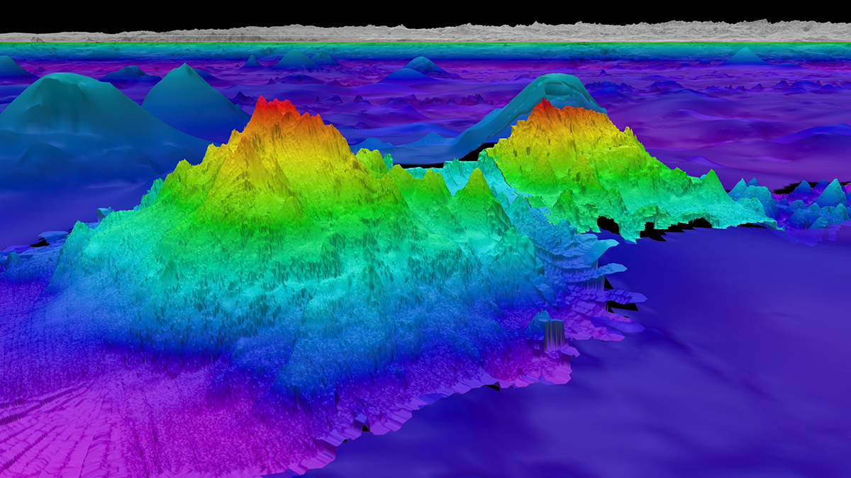
An oft-repeated observation is that we know more about the surface of Mars than Earth’s seafloor. But that has been changing with recent discoveries. Off the coasts of Central and South America, researchers with the Schmidt Ocean Institute, a Seabed 2030 partner, found four seamounts in January 2024, including a massive one covering 450 square kilometers that is 2,681 meters tall, which is about 5 times the height of New York City’s One World Trade Center.
At a depth of 1,150 meters, the giant seamounts were well hidden beneath the waves. To find these features, researchers aboard the institute’s R/V Falkor (too) looked for clues on the surface of the ocean. Satellite altimetry data can show variations in the height of the ocean surface caused by gravity anomalies. A slight depression could point to a trench, and a rise could reflect the presence of a seamount.
“The most significant aspect of our findings is the validation of the satellite altimetry data that we used to target these seamounts,” said John Fulmer, lead technician aboard the Falkor (too). “As all of our findings were in international waters, there is no apparent political significance to speak of, but the ease with which we were able to identify potential seamounts is a testament to the importance of collective and open data resources at our disposal.”
Bringing New Tools to Bear
Crowdsourcing and the use of open-source data are crucial to the Seabed 2030 project. It relies on data donations from a range of sources: scientists and philanthropists; offshore survey companies; and fishing, cruise, and cargo vessel operators. In November 2023, for instance, Seabed 2030 announced the donation of a data set covering 8,000 square kilometers of remote areas that are difficult to reach. U.K.-based remote sensing company ARGANS (Applied Research in Geomatics, Atmosphere, Nature and Space) provided the high-resolution bathymetric data derived from satellite observations, one of the main data-gathering methods along with aircraft-based lidar sensing and sonar readings. In another example, the Japan Coast Guard donated to GEBCO a large bathymetry data set covering areas around Japan and Antarctica, according to Haruka Ogawa, a researcher in the coast guard’s Hydrographic and Oceanographic Department.
All Seabed 2030 data are uploaded to the free-access GEBCO grid of the seafloor. The grid shows that 24.9% has been mapped to the Seabed 2030 resolution, leaving about 75% to be done over the next 6 years if the project’s goal is to be met. That’s a massive undertaking considering challenges such as permanent ice cover near the poles and the fact that about half of the global ocean is deeper than 3,200 meters.
Because vessels are usually needed for the job, it makes for a slow, costly endeavor with a bias toward areas with expertly equipped ships, said Katleen Robert, a seafloor and habitat mapping researcher at Memorial University of Newfoundland, in Canada. She said she sees autonomous vehicles, both underwater and surface, as having the largest impact on how much of our oceans we will map in the near future.
“These will act as force multipliers and enable us to acquire higher-resolution data and repeat data sets to monitor changes over time,” said Robert, who is not directly involved with Seabed 2030, although expedition data she was involved with are supporting it.
In 2023, Seabed 2030 partnered with U.S. company Saildrone to promote the use of uncrewed hydrographic vessels. Powered mainly by wind and solar, Saildrone’s 20-meter surveyor drone can gather multibeam sonar data to depths of 7,000 meters for a fraction of the operating cost of crewed ships. One surveyor found a 1,000-meter seamount off California during a months-long surveying mission that saw 35-knot winds and 5-meter swells, according to the company.
“We know that we will be much closer to a fully mapped planet than the 6% that had been mapped when the project started.”
Other researchers are hoping other forms of artificial intelligence will accelerate the mapping mission. In addition to surface and underwater exploration vessels, researchers at the Japan Agency for Marine-Earth Science and Technology (JAMSTEC) are deploying deep learning techniques to enhance the resolution of existing topographic data.
The approach using convolutional neural networks is “surprisingly effective” and can be used as a complementary method to direct depth sensing, said Eiichi Kikawa, a data scientist at JAMSTEC. He added that a paper on the research has been submitted for publication.
It’s too early to tell whether these tools could help Seabed 2030 meet its goal in 6 years, but the project is relying on more partnerships to increase coverage of the seafloor.
“We are aware of the magnitude of the challenge that still remains and are working with the global community to push to complete the job by 2030,” McMichael-Phillips said. “However, with the progress that has already been made, and with the time left until the end of the decade, we know that we will be much closer to a fully mapped planet than the 6% that had been mapped when the project started.”
—Tim Hornyak (@Robotopia), Science Writer