The United States are spoilt when it comes to mountain ranges and stunning wilderness areas. In this article, we’ll look at just a few of the most beautiful mountains in the US. From snow covered peaks to rocky summits that can be reached in a few hours, North American mountains come in all shapes and sizes.
Whether you’re looking for a new climbing challenge or simply want some some good photo opportunities, I hope you find a mountain here to inspire you!
Since beauty (even montane beauty) is in the eye of the beholder, the following are in no particular order;
Most Beautiful Mountains In The US
1. Denali, Alaska
At 6,190m (20, 310ft) Mount Denali is the highest mountain peak in North America and one of the seven summits. Every year, people from all over the world travel to Denali National Park in the hopes of summiting Mount Denali. This giant has a base diameter of over 4 miles (6.4 kilometers).
The Athabascan people have lived in the region for thousands of years. In their language, “Denali,” means “the high one” or “the great one”. It is considered a sacred site and a symbol of their cultural identity.
The mountain is also known as Mount McKinley. This name was given to it by a gold prospector in 1896 in support of a presidential candidate of the time.
2. Mt Saint Elias, Alaska & Yukon Border

Mount Saint Elias (Photo courtesy of David Sinson on Wikicommons)
Mount Saint Elias is the jewel of the Saint Elias Mountains. This range is on the border between the state of Alaska in the United States and the province of Yukon in Canada. It is the second-highest mountain in both countries with an elevation of 18,008 feet (5,489 meters).
Mount Saint Elias is an ideal place for mountaineering. Three are several challenging routes leading to the summit. It is surrounded by several other notable peaks, including Mount Logan, the highest peak in Canada, and Mount Augusta, which is the third-highest peak in the United States.
3. Mauna Kea, Hawaii
Mount Kea is a dormant volcano located on the Big Island of Hawaii. It is the highest peak in Hawaii with its summit rising to a height of 13,796 feet (4,205 meters) above sea level. If you measure it from the base on the ocean floor, it is the tallest mountain in the world!
Mouna Kea is a shield volcano. It has a broad, flattened shape that is the result of low viscosity lava flows. The mountain is also home to several cinder cones, which are smaller volcanic features which formed after eruptions in the past. The summit is covered by snow and ice year-round.
Ton the Hawaiian people, the mountain is a sacred site and the home of their gods and goddesses. Mauna Kea is not only one of the most beautiful mountains in the world, it also offers particularly good conditions for astronomical research.
Looking for more hikes and mountains in Hawaii? You may like 15 Top Hikes in Kauai
4. Mt Hood, Oregon

This prominent stratovolcano is located in the northern part of the U.S. state of Oregon. It is part of the Cascade Range and stands as the highest peak in Oregon (11,249 feet / 3,429m).
Geologically, Mount Hood is considered a potentially active volcano, although it has not erupted since 1907. The mountain features several glaciers, the most notable being the Eliot Glacier, Coe Glacier, and Reid Glacier.
One of the most popular attractions on Mount Hood is the Timberline Lodge, a historic mountain lodge located near the timberline on the southern side of the mountain. Built during the Great Depression, the lodge is famous for featuring in the film “The Shining.
5. Mt Rainier, Washington

Mount Rainier is the highest peak in the Cascade Range of the USA. It is 14,411 feet (4,392 meters) above sea level, making it the highest peak in the state of Washington. The is a massive mountain with a base diameter of over 35 miles (56 kilometers) and a volume of more than 80 cubic miles (330 cubic kilometers).
Mount Rainier is an important site for ecological research and conservation. The mountain and surroundings include glaciers, alpine meadows and old-growth forest. This is important natural habitat for black bears, mountain goats, and Roosevelt elk. Rare species of plants like the subalpine fir and the western white pine also grow here.
Mount Rainier is also a popular destination for outdoor recreation. People visit the area for a variety of activities, including hiking, skiing, snowshoeing, and camping.
You may also like: Best hikes in Washington
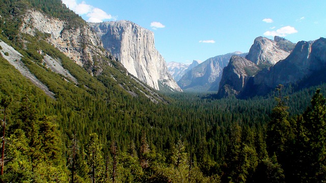
6. Half Dome, California

Half Dome is a granite batholith located in the eastern part of Yosemite National Park. The dome looks like it has been split , hence the name. The Ahwahnechee people called it “Tis-sa-ack” (cleft rock).
Half Dome rises to a height of 8,839 feet (2,694 meters) above sea level. This is one of the most recognizable rocks in the whole of the US. The granite surface has been smoothed by centuries of wind and water action.
Half Dome has a rich climbing history, it was first ascended by Greg Anderson in 1875. Anderson drilled holesand placed bolts in the rock face. In 1919, the National Park Service designated Half Dome as a wilderness area, and established strict rules and regulations for climbing the dome.
Today, visitors must obtain a permit to hike Half Dome. To ascend the dome, you must use the system of fixed cables on the iconic via ferrata route. This cables section with a steep drop makes it one of the scariest hikes in the world.
Also read: Yosemite Falls Hike & Pohono Trail
7. The Tetons, Wyoming

The Teton Range, commonly referred to as the Tetons, is a stunning mountain range located in the western part of the U.S. state of Wyoming. It is a part of the larger Rocky Mountains system and is known for its jagged peaks, pristine lakes, and abundant wildlife.
The highest point of this range is Grand Teton, standing at an elevation of 13,775 feet (4,199 meters). The range stretches for about 40 miles (64 kilometers) from north to south and is located just to the west of the town of Jackson, Wyoming. The range is also a major feature of Grand Teton National Park, which encompasses much of the mountain range and its surrounding area.
8. Mount Whitney, California

Mount Whitney is a majestic peak located in the Sierra Nevada mountain range of California. It is the highest peak in the contiguous United States, with an elevation of 14,505 feet (4,421 meters) above sea level.
Mount Whitney was named after Josiah Whitney, the state Geologist of California. Whitney was the key benefactor of a geological expedition in 1864. Today, the Mount Whitney trail is a popular hiking stretching 22 miles (35km) and taking hikers to the top of this mountain.
Mount Whitney is located in the John Muir Wilderness Area., This protected wilderness area that includes alpine meadows, lakes, and forests. This is home to unique species, including the endangered Sierra Nevada bighorn sheep.
Also read: Best Hikes In Southern California
9. Mount Baring, Washington
Baring Mountain is a stunning peak located in the Cascade Range . It was known as Mount Index up until 1917. The name change was in order to avoid confusion with another mountain called West Index Mountain.
It is a dramatic looking mountain and the third steepest of Washington’s peaks. Despite this, it has a relatively low elevation of only 1, 868m / 6127ft. The standard trail is not along the Northwest ridge route and is not very technical. There are only a few scramble sections. The Northeast is a steep climbing route.
Mount Baring is a popular location for base jumping. The first base jumpers launched off this mountain in 2001.
10. Mount Shashta, California

Mount Shasta is located in Siskiyou County, California, USA. At 14, 179ft (4,322m) It is the fifth-highest peak in California. It’s at the southern end of the Cascade Mountain range. This is a potentially-active volcano that erupts every 600-800 years.
The four overlapping cones of this stratovolcano give it a layered look. One of these cones is the small, satellite cone known as Shastina. Together with its surrounding area, the volcano is part of the Shasta-Trinity National Forest.
The area around Shasta has a rich history. The earliest people lived here around 7, 000 years ago. In the 1820s, The mountain was a prominent landmark along Native American trade route between the Central Valley and Pacific Northwest.
11. Maroon Bells, Colorado

The Maroon Bells are a pair of 14,000 foot mountain peaks located in the Elk Mountains of Colorado, USA. They are one of the most photographed landscape features in the state.
The Maroon Bells are a result of more than 300 million years of geological processes. composed of a combination of shale, limestone, and mudstone. The characteristic red hue of these beautiful mountains comes from the weathering of iron-rich heamatite. The mountains are named for their unique bell-like shape and their reddish color, which is particularly vibrant at sunrise and sunset.
The surrounding area is designated as the Maroon Bells-Snowmass Wilderness Area. Here there are some of Colorados best hiking trails including day hikes and overnight routes. More than 300, 000 people visit this area each season.
12. Mount Bona, Alaska

Mount Bona 16, 550ft / 5, 029m is the highest volcano and the fifth-highest peak in the United States. It is located in the Saint Elias Mountains, which are part of the Wrangell-Saint Elias National Park and Preserve.
The mountain was named by Prince Luigi Amedeo, the Duke of Abruzzi while making the first ascent of Mount Saint Elias, from where Mt Bona is visible. He gave the name ‘Bona’ after his racing yacht.
Mount Bona is considered a dormant volcano, and it last erupted around 10,000 years ago. The mountain is almost completely covered by glaciers and ice fields. The standard route to the summit involves a multi-day expedition and requires technical climbing skills. Mt Bona has several subsidiary peaks, including Mount Churchill and Mount Blackburn.
13. Mount Foraker, Alaska

Mount Foraker is a 5,304m/ 17, 400ft peak in the Alaska Range. It is located in Denali National Park and is the second-highest peak in Alaska and the 3rd highest mountain in the United States. It sits almost directly above base camp for climbing Denali.
The mountain was named in 1899 after Joseph B. Foraker. The U.S. Senator from Ohio. Native Koyukon people called it two names; ‘Sultana’ (the woman) and ‘Menlale’ (Denali’s wife). The gentler, northeast ridge is still known as Sultana Ridge.
Mount Foraker has a north and a south summit. Both summits were first successfully climbed in August 1934.
14. Mount Mitchell, North Carolina

Mount Mitchell(6, 684ft / 2,037m) is the highest peak east of the Missisippi river in the United States. It is part of the Black Mountains of North Carolina,a sub-range of the Appalachian Mountains.
The mountain is named after Elisha Mitchell. Mitchell was a professor at the University of North Carolina who measured its height in the mid-19th century. In Cherokee, this mountain is called Attakulla.
Mount Mitchell is covered in a dense spruce-fir forest, which is only found at high elevations in the Southern Appalachian Mountains. The summit of the mountain is a sub-alpine environment, with windswept trees and rocky terrain. It is home to several rare species of birds, including the Northern Saw-whet Owl and the Red Crossbill.
Mount Mitchell is one of the coldest places in the Southeastern United States. It has an average temperature of only 45°F (7°C) and the summit is often covered in snow and ice, even in the summer months.
Mount Mitchell can be done as an add-on when hiking the Appalachian Trail.
15. Mount Borah, Idaho

Mount Borah or ‘Beauty Peak’ is part of the Lost River Range, in the Salmon-Challis National Forest. It is the highest peak in the state of Idaho, standing at 12,662 feet (3,859 meters) above sea level. The mountain gets its name from William Borah, a prominent Idaho politician and state senator.
This area is known for its rugged terrain and challenging hiking trails. The standard route to the summit is a 3.5-mile (5.6km) hike with an elevation gain of over 5,000 feet. The mountain has some technical climbing routes and is popular amongst experienced mountaineers.
Borah Peak is the tallest of the “Nine Peaks,” a group of nine mountains in Idaho that are over 12,000 feet. The mountain is located in a seismic zone. In 1983, a magnitude 7.3 earthquake caused a massive landslide on the peak’s north face which resulted in several fatalities.